Coastal activities like fishing, boating, and surfing are greatly enhanced by understanding the ebb and flow of the tides. Tide charts provide a roadmap for navigating these fluctuations, revealing when high and low tides occur. By learning how to read tide times, you can plan your day effectively and maximize your enjoyment of coastal adventures. This article will guide you through the fundamentals of tide reading, equipping you with the knowledge to confidently interpret tide charts and make informed decisions about your activities.
This comprehensive guide will delve into the intricacies of tide times, exploring their significance, various tools for accessing information, and practical applications for different coastal pursuits.
Understanding Tide Times
Tide times refer to the specific moments when the water level reaches its highest (high tide) and lowest (low tide) points during a given day. These fluctuations are primarily caused by the gravitational pull of the moon and sun on Earth’s oceans. The moon’s gravity exerts a stronger influence, creating bulges of water on opposite sides of the planet. As the Earth rotates, these bulges move across coastlines, resulting in high tides. Low tides occur in the areas between these bulges.
The duration between consecutive high and low tides is known as a tidal cycle, typically lasting around 12 hours and 25 minutes. However, variations can occur due to factors such as the moon’s position relative to the sun (spring tides) and local geography. Understanding these basic principles lays the foundation for interpreting tide charts and predicting water levels.
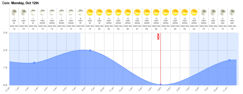
Importance of Tide Charts
Tide charts are invaluable resources for anyone engaging in coastal activities. They provide a visual representation of predicted high and low tides for specific locations over a period of time, typically several days or weeks. By consulting tide charts, you can plan your activities around optimal water levels, ensuring a safe and enjoyable experience.
For example, fishermen often rely on tide charts to determine the best times for fishing in certain areas, as tides influence fish behavior and accessibility. Boaters use them to navigate channels and avoid shallow waters during low tide. Surfers consult tide charts to identify suitable wave conditions based on tidal height and currents.
Tidal Ranges and Water Levels
Tidal range refers to the vertical difference between high and low tides within a specific location. It is expressed in feet or meters and indicates the extent of water level fluctuation throughout a tidal cycle. Understanding tidal ranges helps you anticipate water levels and plan accordingly for various activities.
A large tidal range signifies significant fluctuations in water depth, while a small tidal range indicates relatively minor changes. Factors such as the moon’s position, local geography, and ocean currents influence tidal range variations.
Online Tide Prediction Tools
In today’s digital age, numerous online tide prediction tools provide accurate and up-to-date tide information for locations worldwide. These websites and apps utilize sophisticated algorithms to calculate tide predictions based on various factors, ensuring reliable data for planning your coastal activities.
Popular online tide prediction tools include NOAA Tides & Currents, Tide-Forecast.com, and Windy.app. Simply enter your desired location, and these platforms will display detailed tide charts, including high and low tide times, tidal ranges, and other relevant information.
Local Tide Tables
Alongside online resources, local tide tables are readily available in many coastal communities. These printed publications often provide comprehensive tide information for specific harbors or regions, offering a convenient alternative to online tools.
Local tackle shops, marinas, and tourist information centers frequently distribute tide tables. They may also include additional details such as current conditions, weather forecasts, and fishing reports, making them valuable resources for coastal enthusiasts.
Conclusion
Mastering how to read tide times is essential for anyone who enjoys coastal activities. By understanding the principles of tides, utilizing tide charts and prediction tools, and considering local factors, you can plan your adventures with confidence and maximize your enjoyment of the water. Whether you’re fishing, boating, surfing, or simply exploring the shoreline, incorporating tide information into your plans will enhance your overall experience and ensure a safe and rewarding time.